Gridded
GSSHA v.1.4.5.7
Gridded Surface Subsurface Hydrologic Analysis (GSSHA) is a grid-based two-dimensional hydrologic model.
Panoply v.3.1.4 Build C6U1
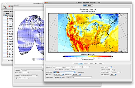
Panoply is a cross-platform software which plots geo-gridded arrays from netCDF, HDF and GRIB datasets. Panoply is an utility that enable user to plot raster image. Depending on the data,
Panoply for Mac 3.1.7 Build CCX v.X
Panoply for Mac is a cross-platform application which plots geo-gridded arrays from netCDF, HDF and GRIB datasets.

Panoply 64bit 3.1.7 Build CCX v.X
Panoply 64bit is a cross-platform application which plots geo-gridded arrays from netCDF, HDF and GRIB datasets.

Panoply 3.1.7 Build CCX v.X
Panoply is a cross-platform application which plots geo-gridded arrays from netCDF, HDF and GRIB datasets.
Java Ocean Grid v.1.0
Java Ocean Grid (JOG) is a Java package which provides the user with a simple and effective object oriented approach to manipulating/analyzing gridded oceanographic and meteorological data.
Integrated Data Viewer v.2 9
The Integrated Data Viewer (IDV) from Unidata is a Java™-based software framework. The IDV 'reference application' is a geoscience display and analysis software system with many of the standard data displays that other Unidata software (e.g.
SutraPlot 2D3D.1 v.1.0
A Windows-based visualization tool for 2D and 3D SUTRA simulations SutraPlot Version 2D3D.1 creates 2D and rotatable 3D plots from 2D and 3D SUTRA output data. It runs on the Microsoft Windows operating system.
PhysPlot v.1.0.0.2
PhysPlot is a general purpose meteorological plotter with the ability to plot isobars, wind arrows, fronts, pressure systems sea temperatures and other data from a variety of sources.
The Simple Hydraulic Calculator v.1. 4. 2008
Powerful and affordable hydraulic calculation software for automatic fire sprinkler systems. TSHC has all the features you need to enter system data, evaluate and analyze results, and produce professional hydraulic calculation reports.
Encom Discover v.12.0
Encom Discover is the desktop Geographical Information System (GIS) designed especially for the geosciences, providing the tools to effectively compile, visualise, analyse and map spatial geoscience data.
NOAA Weather and Climate Toolkit v.5.0
NOAA's Weather and Climate Toolkit is an application that provides simple visualization and data export of weather and climatological data archived at NCDC.